File:14-236-LunarGrailMission-OceanusProcellarum-Rifts-Overall-20141001.jpg
From Wiki @ Karl Jones dot com
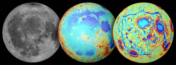
Revision as of 03:18, 26 May 2016 by Karl Jones (Talk | contribs) (Earth's moon as observed in visible light (left), topography (center, where red is high and blue is low), and the GRAIL gravity gradients (right). The Procellarum region is a broad region of low topography covered in dark mare basalt. The gravity gradi...)
No higher resolution available.
14-236-LunarGrailMission-OceanusProcellarum-Rifts-Overall-20141001.jpg (614 × 228 pixels, file size: 32 KB, MIME type: image/jpeg)
Earth's moon as observed in visible light (left), topography (center, where red is high and blue is low), and the GRAIL gravity gradients (right). The Procellarum region is a broad region of low topography covered in dark mare basalt. The gravity gradients reveal a giant rectangular pattern of structures surrounding the region.
File history
Click on a date/time to view the file as it appeared at that time.
| Date/Time | Thumbnail | Dimensions | User | Comment | |
|---|---|---|---|---|---|
| current | 03:18, 26 May 2016 | 614 × 228 (32 KB) | Karl Jones (Talk | contribs) | Earth's moon as observed in visible light (left), topography (center, where red is high and blue is low), and the GRAIL gravity gradients (right). The Procellarum region is a broad region of low topography covered in dark mare basalt. The gravity gradi... |
- You cannot overwrite this file.
File usage
The following page links to this file: